Ames to Crosby. 21 miles/1608.6 total
Wednesday, February 17, 2010
It's another clear sunny day as I set out from next to the railroad tracks in Ames, heading down through Liberty and Dayton, to a spot a little east of Crosby. The first half of the walk will be through these small cities and their outskirts, and the second half will be in the wide open spaces.
The temperature is in the low 40s, expected to get into the high 50s. It got down to around freezing overnight, so it will take some time to warm up.
Very shortly after I begin I leave Ames and enter Liberty, population 8,033. Liberty calls itself “The First City on the Trinity.” That’s the river on the west side of the city. Liberty claims to be the third oldest city in the state, by which I think they mean the third oldest settlement of Americans in what was then Mexican territory. The area was settled by Spanish people in 1752, then in 1831 it became a mostly Anglo city, called Villa de la Santisima Trinidad de la Libertad, meaning, I believe, City of the Most Holy Trinity of Liberty, a bit of a compromise, perhaps, between the interests of the Mexicans and those of the Gringos.
I take the little spur off U.S. 90 into the city center. According to its water tower, Liberty is the home of the Panthers, which I guess is their high school football team. At the corner of Main and Sam Houston stands the Liberty County Courthouse, vintage 1930, a limestone building looking the very picture of the art deco-influenced public architecture of that era, with a nice stylized eagle above the front door, and bas-relief carvings of long horn cows and a train engine and a wagon train, intended to depict the economic underpinnings of the county.
Inside it’s not fancy, but has nice tiled floors. Out on the lawn is a monument to William Logan, the first sheriff of Liberty County, who fought in the Battle of San Jacinto in 1836, the decisive battle of the Texas war for independence from Mexico.
I go past the courthouse and around the First Methodist Church, a handsome light brown brick building dating from the 1950s. Then down to the City Hall and past the Park Theater, now called the Liberty Opry. The plaque in front of Immaculate Conception Church says this block was designated for Catholic use in 1831 by the Mexican government. In 1846 the Methodists built a church here, but they moved to their present site and the Catholics took this block over again.
Between the railroad tracks and Highway 90 runs Dr. Martin Luther King, Jr. Drive, which isn’t too shabby as King Drives go. Actually, there’s nothing on it except for a couple of warehouses.
Out past the edge of Liberty I go over the wide high Trinity River, and out onto an alluvial plain, mostly flooded now. The wind is blowing over the water and into my face at about ten miles an hour, adding to the chill.
I see lots of CDs on the side of the road, mostly homemade ones, but here’s something I rarely see. It’s an old 45 rpm record, broken, but with the label intact. It’s Dinah Washington singing “Harbor Lights.” On the B side she’s singing the Hank Williams song, “Your Cold Cold Heart.”
In the middle of the wetlands I leave Liberty and immediately enter Dayton, population 5,709. Dayton was originally called West Liberty, and was part of the original city of Liberty. Gradually it became known as Day’s Town, after a prominent citizen, then Dayton, which became its official name in about 1885.
Dayton was the site of a claimed UFO sighting on December 29, 1980. Two women and the seven-year-old grandson of one of them were driving home when they saw a huge diamond-shaped object hovering at about treetop level, expelling flames and emitting significant heat. They got out to take a look. The grandmother, a born-again Christian, thought it was the second coming of Christ, and told her grandson, “That’s Jesus. He will not hurt us.” The joke was on them. The heat became so intense that it hurt to put their hands on the car. The object then moved higher in the sky and the three got back into the car and went home. But Jesus had put the hurt on them big time. The next day all three began to experience nausea and diarrhea, and soon developed skin lesions and experienced hair loss, all symptoms similar to those of radiation poisoning, or perhaps chemical contamination. Except that they pretty much got better. Eventually the women sued the government for 20 million dollars (because they had seen some military helicopters around the diamond-shaped object), but the lawsuit was dismissed based on the government’s testimony that it did not have a large, diamond-shaped aircraft in its possession. Nor, I imagine, did it have a Jesus in its possession.
To me, the telling fact is that these things always happen in the BFE parts of the country, where people are already somewhat addle-pated just from their cultural environment. "That's Jesus." Or not.
About a mile and a half after I enter the Dayton city limits I begin to climb up and out of the Trinity River basin, toward the town. There’s a historical marker entitled the Runaway Scrape, about the flight of Anglo settlers along this route in 1836, after the Battle of the Alamo. Colonists abandoned their homes and sought refuge in East Texas and Louisiana, assuming they would be slaughtered by the Mexicans. Then they got news of the victory of Sam Houston’s army at the Battle of San Jacinto.
One of the things to keep in mind amid these stirring tales of the Texas war for independence is that they were fighting in part for the right to own slaves. The Mexicans had outlawed slavery in 1829, but the English-speaking Texans were granted a one-year extension. Then in 1830 the president of Mexico ordered all slaves to be freed. This pissed off the noble, freedom-loving, white Texans, and the result a few years later was armed rebellion. Of course the long-range plan in the minds of many was for anschluss with the U.S. as a slave state, which eventually happened.
So for at least 5,000 black people the result of the Texas war for independence was that they could kiss their own independence good-bye.
A little west of Dayton I pass a pasture where a huge black Angus bull is grazing near the fence. Due to my success yesterday I try a little singing, and start in on Dylan’s “She Belongs To Me.” The bull turns his head slowly and gives me a look, as if to say, “You’ve got to be kidding. That crap might work on those young steers, with no balls and nothing to do but prance around all day, but I am totally unimpressed."
I stop at the Racetrac gas station to get a couple of things, because this will be the last store of any kind for the rest of the walk, some twelve more miles. Then it’s out into the countryside.
Soon I come to another historical marker. It’s about the town of Stilson, the place the map says is supposed to be here. During the late 1800s a railroad guy named O.H. Stilson set this place up and advertised for people from Iowa to come down and farm the area, which many did, including some Swedes. The town thrived for a few decades, then began to decline when the population gradually began to move to Dayton. The post office closed in 1925, and rural mail delivery out of Dayton took over. Now there’s hardly anything left, except for this marker.
A few miles on down, at a wide spot in the road, an old man is selling elaborate bird houses. He has several of them on the hood and roof of his vehicle. I ask him how much they are selling for and he says $95 each. He doesn’t want to put his window down when I approach, so I have to shout. I realize he’s probably afraid of me, a guy on foot with bulges in his sweatshirt. And he also knows I won’t be buying one of these huge birdhouses and walking off with it. So he gives me the bum's rush.
Wednesday, February 17, 2010


Tuesday, February 16, 2010
Day 87: Centennial Penny


Nome to Ames. 20.9 miles/1587.6 total
Tuesday, February 16, 2010
Mardi Gras. I’m leaving from Nome, going through a couple of small places to get to the equally small city of Ames.
It’s clear and sunny, and the temperature is in the high 30s, expected to get into the low 50s. Let’s see if it makes it. There’s a strong cold wind blowing in from the west.
I spent the day off in Beaumont yesterday, and I can tell you that the city is alive and well, especially in the western and northern sections, where every imaginable big box store and chain boutique and restaurant line the affluent boulevards.
I went into the center of the city and visited the Art Museum of Southeast Texas. It has a very small permanent collection, including an Andy Warhol rendering of a Mobiloil sign, a couple of things by Robert Rauschenberg, the Port Arthur native, and two or three paintings by Paul Manes, a Beaumont native. Also they were having an exhibition of a private collection of African American art, including some very nice paintings from the 19th century and a contemporary one I particularly liked called “Dancing,” by Elizabeth Catlett.
Next I went to the American Fire Museum, filled with artifacts of the history of firefighting—old horse drawn wagons, hand pumps, nozzles, early motorized fire trucks—along with explanations of the various innovations as they came into being. Very nicely done. Beaumont, since 1969, has been the home of the American Valve and Hydrant Manufacturing Company, a major maker of hydrants.
Well, back to today. It’s going to be a day of walking in the country. Gradually the tall southern pine trees have become more prevalent. I’ve left Jefferson County and have entered Liberty County.
Here’s a find. A one hundred year old penny. A 1910 Lincoln penny—only the second year they made them. And it’s in good condition, with the lines on the sheaves of wheat clearly visible. The only trouble is that it’s been nicked quite a bit on the obverse and around the edges from being run over, which pretty much shoots its value down. Still, a great find.
The road has narrowed from four lanes to two and the pine trees have closed in on either side. And that, other than the penny, is the only thing worth remarking on so far. I guess it’s time to break out the iPod.
About halfway through the walk I enter the City of Devers, population 416. I see a new road kill species—a pig. A baby feral or wild pig, just a tiny thing, with black hair. At first I think it's a puppy, but then I get a look at the nose and feet, and sure enough, it’s a piglet.
And speaking of dead animals, as I walk into the 2 G’s Country Store and Exxon Station, out front by the road is what looks like the carcass of a wolf or a black German Shepherd. It makes me think of the black wolf that stalked Meriwether Lewis. It’s been there for some time, and only the head, with pointed ears and nose, remains intact and recognizable. Sort of like a very dirty dog-skin rug. The Indian proprietors of 2 G’s don’t seem to care that it’s there, right where cars and trucks turn in to the pumps. Maybe where they come from when a dog dies it stays in the spot where it died until the vultures and crows finish it off. Well, here too. Still....
Outside the store I go around to the porch on the south side and stack a couple of plastic milk crates and sit in the sun, drinking coffee and trying to soak up some heat. The dead dog is about fifty feet away. I’m still wondering whether it’s a dog or a wolf, but I don’t really care to check it out further. Whatever it is, it’s canine, and in a week or two it will be gone.
About twenty white faced cattle are grazing in a pasture west of Devers. Just to see if I still have the touch, I start singing “Werewolves of London,” and sure enough, those damn cows come up to the fence where I’m standing. Not walking, running. As I continue along they follow me, all the way to the end of the fence, a thousand feet down. I missed my calling. I should have been a cowboy.
I enter the next town, Raywood. This one doesn’t have a population on the sign, probably because it’s unincorporated. There are a few things going on here, nevertheless. Three gas stations, a rice storage place. A great big fruit stand. Scott’s Country Cookin’ Barbecue.
Nearing the end I enter Ames, population 1079. Ames has Cookie’s Soul Food Kitchen and Wickliff’s Gas and Grocery. Only there’s no gas. Ames is a mostly African American city, just as Devers and Nome are mostly white cities, but that’s about all I could find out about any of them.
Sunday, February 14, 2010
Day 86: The Long Goodbye
Beaumont to Nome. 20.6 miles/1566.7 total
Sunday, February 14, 2010
I’m heading out this morning from the parking lot across from the Ebenezer Missionary Baptist Church in downtown Beaumont, through the city and out Highway 90 to the small city of Nome.
It’s much warmer today. Partly cloudy, expected to rain later in the afternoon, but dry now. Temperature is in the mid 50s, expected to get into the mid 60s. This is more like normal for this time of year around here.
I go past the large Beaumont Public Library, downtown branch, and north up Main Street. The streets are cavernous and empty, which I would expect on a Sunday morning.
Here’s a green copper sculpture of four men, slightly larger than life-sized. They’re wearing suits and look very 20th century. Underneath it says “Men of Vision” and it honors Vic, Sol, Ben and Nate Rogers. They were brothers from a family that come down to Texas from Chicage in the first half of the 20th century and founded an optical company and dealt in real estate. And they got involved in civic things. They probably had something to do with the Texas Energy Museum, in front of which this sculpture is located, or perhaps the next door Art Museum of Southeast Texas. If I were planning things out more carefully, I’d like to visit both these places. But it just happens that I’m here on Sunday morning. Maybe I’ll get back here.
I walk past Bowie Street and turn west on Crockett Street. The first block of Crockett is brick, and blocked off to traffic. It contains a string of fashionable restaurants and bars. There’s nobody here at this hour except me and a guy who is checking the ashtrays under the outside awnings for smokable cigarette butts. He ignores me as I pass, intent on his work. Well at least somebody's downtown.
Even the parking lots of the huge central churches are quiet and mostly empty. At Orleans and Liberty there’s a beautiful block-long art deco building called Kyle’s, most of it empty.
Here’s the federal building and the First Methodist Church, rivaling St. Anthony Cathedral in its dimensions. Down by Broadway and Forrest I go by Congregation Temple Emanuel. The congregation began in 1887, and this building was built in 1923. Rotund and solid.
Although it has its share of vacant lots and empty storefronts, downtown Beaumont looks like it probably bustles during the week when the courts and banks are open, then closes up tight after dark, which is pretty standard for many American cities.
I’m out on U.S. 90 now, saying the long goodbye to Beaumont, which drags on for several miles of fast food joints and small businesses.
Well out into the country and almost halfway through the walk I leave the city limits of Beaumont. I come to a cemetery called the Claybar Haven of Rest Cemetery and Crematory. Here the graves are American style, and the dead have mostly English names. I sit on a pink marble bench that reads “Balcom” across from Mrs. B, who died a few years ago, and is waiting for Mr. B. to join her. He’s probably in no hurry. So much grief has filled this piece of ground. So much sadness. Sometimes I feel that more than the peace of the place.
The railroad tracks run parallel to Highway 90, and at least four long freight trains have passed this afternoon, all heading west. At 15 miles I enter China, population 1112. The smell of cow shit greets me. A child’s bicycle lies half-submerged in the ditch. The sun shines brightly, and I think I’m going to beat the showers that are moving in slowly from the west.
The name of this place comes from the fact that the railroad water stop in the late 1800s sat in a grove of China Berry trees. A post office was set up under the name China Berry, and later the name was shortened to China.
I stop at the Snappy Mart Exxon station. Inside as the Indian guy is ringing up my drink I am tempted to say to him, “When you came here all the way from India did you expect to end up in a place called China?” I don’t. He bobbles his head pleasantly and says, “Have a good vun.”
Here’s Mr. Snip’s barber shop. The center of China lies a block north of the intersection and there are a few streets of houses to the south. Out in front of the Church of Our Blessed Lady of Sorrows there’s a little brick serenity garden, nicely planted with bushes and low trees. I take a seat on the bench and relax. A sign in front of me says “In Memory of Uncle Earl Kibodeaux.” I raise my diet Coke to Uncle Earl.
The sign at the other end of China is exactly like the one I passed when I entered the place a couple of miles back. I’ve noticed that they do that in Texas, at least so far. They use the same sign to designate the end of the city limits, with the population on it, as they use at the beginning. This is potentially confusing, especially if you aren’t paying attention and happen to miss the first sign. You’ll think you’re entering a place when you’re leaving it.
The change is coming in pretty well in Texas so far. I have found $1.18 in three days, about half of that today. Change and silverware. And a few hand tools. Not much road kill yet.
Very near the end of today’s walk, at the intersection of U.S. 90 and Texas Route 326, I see the sign that says I’m entering Nome, population 515. The internet says it was a stop on the Texas and New Orleans Railroad called Congreve Station back in the 1860’s, but when they discovered oil in the early 1900s and people started coming in, the name got changed to Nome because the influx reminded them of the Alaska gold rush. A bit of a stretch, if you ask me. Despite its rather small population, Nome incorporated as a city in 1971.
And that's it. A rather uneventful day.
Saturday, February 13, 2010
Day 85: Empty Beaumont
Bridge City to Beaumont. 20 miles/1546.1 total
Saturday, February 13, 2010
I’m in the wide median of Texas Route 87 just south of the Rainbow Bridge, heading through Port Arthur and then to Beaumont.
It’s overcast, with no rain predicted for today. It’s in the high 30s, expected to get into the high 40s. Maybe a little sunshine later.
Almost immediately I pass the Golden Triangle Veteran’s Memorial Park and I go in to have a look. It’s a collection of military hardware—a tank, a big gun, a helicopter, an anchor, a jet fighter—plus a miniature Statue of Liberty. In the middle of this arsenal of democracy are the names of the local people who have served in various wars, and the names of those who died. The Golden Triangle, by the way, is the area of Orange, Port Arthur, and Beaumont.
Across the road from the memorial is a large refinery or petrochemical plant, I’m not sure which, spewing out lots of steam, so much so that it creates its own weather along this part of the highway.
On Route 87 heading to Port Arthur I pass a succession of little one-story buildings--the Club Jaguar, a small Masonic Lodge, a little bar painted turquoise called Los Tres Reyes, a place called The Trilogy, and one whose sign says "Las Chicas Sexy, Opening Soon."
Right before I turn off of Texas 87 I pass the First Baptist Church, a brobdingnagian red brick structure sprawling out in all directions. Boy, these white Baptists sure do build ‘em big.
I realize I’m only skirting the outer edges of Port Arthur. I will say that it is the hometown of Janis Joplin and the artist Robert Rauschenberg. There is probably something in honor of these people downtown, but I will miss it. Port Arthur is a city of about 57,000, and was once the center of the largest oil refining region in the world.
I head north by northwest up Texas 347. I go past a large hideous high school, dating from the 60s, with the linear design, aluminum trim, and colored panels that were all too prevalent during that unfortunate era in public architecture.
Up past the high school the neighborhood is tidy and residential, with live oaks growing in the middle of a boulevard running off the highway.
Out here on the road I take comfort in things that used to repel or bore me. Walmarts, half-mile-long strip malls containing beauty parlors, jewelry stores, Radio Shacks, dentist’s offices, Chinese restaurants. Large car and truck dealerships filled with gas-guzzling mega-pickups and nobody gives a damn whether they get good mileage or not.
I cut across busy 347 to Greenlawn Memorial Park. It’s mostly English-style graves and headstones, with a scattering of French above-ground vaults. And some large mausoleums, too. One that’s particularly prominent is the Costello tomb, consisting of a vault on a raised marble platform, with vividly colored statues of the Virgin Mary and Jesus. I mean these statues look like something out of an old Disney cartoon, they’re so bright. Entombed here is Fatima Costello, who was born in 1949 and died in 2003, and next to her is space for Mr. Costello, who evidently put this huge deal up in his grief. Across the little paved road is another Costello tomb, this one containing the old folks, Bob and Dorothy Costello, born in the 1920s.
In more modest graves there are Whites, Lambs, Laceys, Trahans, and a Guidry or two. And Shirley and Vernon Shexnayder, like that priest in Crowley. Since my cousin tells me it is a Belgian name, I wonder if it has a German version, as well, and I think of Emmanuel Schikaneder, the Viennese who wrote the libretto of Mozart’s opera, The Magic Flute.
A few miles up 347 I go through Nederland, a suburb of Port Arthur, with about 17,000 souls. Nederland was settled by Dutch people in the late 19th century, and two of the prominent families were named Rienstra and Doornbos. We have plenty of both up in Kent County, Michigan. Today the mix is more local, with Cajuns and Anglos. According to Wikipedia this area has lots of refinery workers and has been heavily pro-union.
In mid-afternoon I enter the city limit of Beaumont, population 113,866. Beaumont has been around since the 1830s, and like other nearby towns was built on lumber, rice, cattle, and oil. I’m still a long way from the center of the city. In fact, it’s more bucolic here than it has been all day. There’s a cow pasture or two, and an armadillo is nosing around in the shallow ditch as I pass. It lets me get pretty close before shuffling away.
I take the cutoff from 347 onto Texas 380, also known as Martin Luther King Drive. A little way down is Lamar University, with over 13,000 students. It is part of the Texas state university system. Sure enough, it was named, in 1932, after Mirabeau B. Lamar, the 2nd president of the Republic of Texas.
I pass the Dishman Art Gallery at the edge of the campus of Lamar University. It’s amazing how many art museums there are tucked away in universities and cities like Beaumont and Orange, sort of off the beaten track of the art world. And they often have a work or two by someone who is world famous, as sort of the jewel of the collection. The Dishman is closed, so I won’t be able to check it out.
There’s some guy named Farouk running for governor of Texas. I’m seeing his signs along here. His full name is Farouk Shami, and he’s a millionaire from Houston, running for the Democratic nomination. Don’t know anything more about him than that.
It has warmed up and the sun is out here in the late afternoon in Beaumont. After Lamar University and Lamar Institute of Technology there’s an empty space along 380, which is almost an expressway here. Beaumont, the good and the bad of it, is laid out as if they had all the room in the world when they built the city. The streets are wide and the spaces between the large downtown buildings are wide, made even more so by the vacant lots that have been left from demolition. You can almost picture tumbleweeds tumbling down the streets.
Beaumont is the birthplace of Johnny Winter. Johnny and his brother Edgar. Johnny, the insanely thin tattoo-covered albino virtuoso, who just might be the Paganini of the electric guitar. What he lacks in elegance and subtlety and soul he makes up for it in pure speed. I think his collaboration with Muddy Waters in the late 1970s, during which he produced and played on three Muddy albums and toured with him, was some of his best work. Playing with Muddy Waters forced Johnny to slow down a bit and pay attention to his phrasing instead of just playing as many notes as possible in the time allotted. Muddy mellowed him out, I think.
At nearly 20 miles I arrive at the junction of 380 and U.S. 90. Instead of going west I go east on 90 toward downtown Beaumont, where the motor home is parked in a large vacant lot next to the railroad tracks. On the next walk I will go west on 90, after I’ve toured the center of the city.
The streets of Beaumont are quiet. I could walk down the middle of Highway 90. There’s some activity at St. Anthony Cathedral Basilica. St. Anthony is a big red Italianate church, very grand, with four massive gray marble columns across the front. In front are three sets of bronze double doors. Above the doors is the inscription “MATER ECCLESIA, PORTA CAELI.” Mother church, gate of heaven. I tell you, the Catholics know how to roll. None of those converted store-front churches for them. If you’re going to claim to be the church, you’ve got to be bigger than any of the rest, even the Baptists.
St. Anthony was founded in 1879, and this church was dedicated in 1907. It became a cathedral in 1966, and a minor basilica in 2006. They’re having Saturday afternoon service, so I don’t venture in.
From the steps of St. Anthony I can see the motor home, a couple of blocks away, across the Italian American Society Piazza.
Friday, February 12, 2010
Day 84: The Yellow Eye of Texas

Louisiana Welcome Center to Bridge City, Texas. 19.7 miles/1526.1 total
Friday, February 12, 2010
I park in the Welcome Center on I-10 and head west for the bridge over the Sabine River and into Texas, where I will go through Orange and Bridge City.
It’s cold. Earlier this morning before the rain stopped it was coming down as snow flurries. I understand other parts of the south got snow, too. Now it’s overcast and about 35 degrees, probably the coldest day I’ve had so far on this journey.
I’m trying to keep a low profile here on the expressway, where pedestrians are prohibited. I’m way down in the ditch now, and heading toward an abandoned car on the side of the road, so everyone will think it’s my car, and after I pass it they’ll think I’m going to the next exit to get help, or whatever.
Except for the heavy traffic, this is a very safe bridge to walk over. The shoulder is almost two lanes wide, giving about fifteen feet and some rumble strips between me and the oncoming cars.
At 1.6 miles I reach the center of the bridge, halfway over the Sabine River. I am now in Texas, leaving Calcasieu Parish and entering Orange County. And for my friends who understand the reference, let me say, GOD DAWG! I JUST GOT INTO TEXAS!
Just a few feet before the state line I stop to pick up my last money in Louisiana, a quarter. Shortly thereafter I pick up a quarter and a dime, my first Texas money. And, in what might be a sign of some kind, the sun comes out for a few seconds, like the big yellow eye of Texas. (That's what Lewis Carrol might have called a "portmanteau" phrase--combining "The Yellow Rose of Texas" with "The Eyes of Texas," both of which I've been singing as I go, to the limited extent that I can remember the words.) After a little over three miles I get off the interstate and down onto the Highway 90 business route, without incident.
It’s time for a Louisiana statistical wrap-up. I entered Louisiana on January 11 and I’m leaving it on February 12. I walked 20 full days and two partial days in the state, for a total of 407.1 miles, the most in any state so far. I averaged 19.8 miles per full day, including that 12 mile day I had in New Orleans. I found $10.28 in change, plus a dollar bill, easily the most of any state so far. I got 18 ride offers, a little less than one per day. After I got down out of the Florida Parishes and New Orleans and into Cajun country the ride offers became more frequent.
And now the all-important road kill numbers. Here I must say that there were hundreds of animals I didn’t count because I couldn’t identify them. Possums led the way with 70, followed by 61 birds. I counted mostly larger birds, like egrets, ducks, one pelican, hawks, owls. There were many little songbirds I didn’t count because I wasn’t sure they’d been hit by cars. Next came 39 raccoons, 22 rabbits, 14 cats, 13 armadillos, 9 turtles, 8 dogs, 6 skunks, 5 minks, 3 frogs, 2 nutrias, 2 squirrels, 2 groundhogs, 2 snakes, 1 deer, 1 rat, 1 beaver, 1 mouse, and 1 otter.
And to the State of Louisiana I bid a fond adieu. Like each new state I enter, I entered Louisiana with some trepidation and uncertainty, but after a few days began to feel right at home there. I hope the same thing happens in Texas, because I’ll be here for a hell of a long time.
At a little over six miles I enter Orange, a city of approximately 19,000. Orange’s early wealth was built on the timber industry, and it later became a deep-water port. I walk by Lamar State College of Orange. The name Lamar is big in Texas history. I don’t know specifically who the Lamar of Lamar State College is, but a guy named Mirabeau Buonaparte Lamar was the 2nd President of the Republic of Texas, from 1838 to 1841. Later he wrote a poem called “The Daughter of Mendoza,” a minor league ode that continues to make it into anthologies of American poetry. Probably its best verse goes like this:
How brilliant is the morning star,
The evening star how tender,--
The light of both is in her eyes,
Their softness and their splendor.
But for the lash that shades their light
They were too dazzling for the sight,
And when she shuts them all is night—
The daughter of Mendoza.
Well, back to Orange. Its streets are wide. I pass the First Baptist Church, which from a distance I thought was the city hall or the county courthouse. It’s a big broad brick affair with a silver dome on top, looking more like a public building than a church.
Down the street there’s the beautiful W. H. Stark House, a sprawling Victorian job painted two shades of green, and across from that is the modern white Stark Museum of Art. I go inside to check it out.
The Stark Museum was started by Henry Jacob Lutcher Stark, 1887-1965, and his wife Nelda Stark, who died in 1999. It contains much of the private art collection of these two, including paintings by N. C. Wyeth, Albert Bierstadt, Georgia O’Keefe, paintings and sculptures by Frederic Remington, and sculptures by Charles M. Russell. Also some Audubon engravings. Everything is around the western theme—cowboys, Indians, landscapes, and so on. Very nice. Food for the soul on this cold gray day.
Henry Jacob Lutcher Stark was the grandson of H. J. Lutcher, a wealthy timber baron, so he had plenty of money to spend on art to enrich his native Orange. On down the street is another domed building, the First Presbyterian Church, a gigantic pink marble Greek Revival building dating to 1912. This was originally the Lutcher Memorial Church, dedicated to the memory of old H. J. Lutcher himself, who had just died. The place is locked, but the stained glass windows in front have a Pre-Rafaelite look to them. The marker out front says they were prize-winning windows from the 1893 Chicago World’s Fair. The dome is topped by a copper cupola.
I pass the Dies Building, containing law offices. One of the lawyers is named Martin Dies. I’ll bet he’s a descendant of Martin Dies, Jr., the red-baiting Texas congressman who started the House Un-American Activities Committee.
I pass out of Orange, past smells of Mexican food and fried chicken. Little by little the culture of a state emerges, often subtly. I don’t know if this indicates anything, but at the gas station where I just bought a cappuccino there was a rack of magazines up by the cash register, and at the top, next to Seventeen and Teen Vogue was a copy of Combat Arms magazine. Something for the boys.
Over the second of four bridges for today, I enter West Orange, and the sign says the population is 4,187. A memorial garden is filled with bronze vases full of brightly-colored artificial flowers (and, as I discover later, glow-in-the-dark crosses). No Louisiana-style French vaults here. I stop in to check out the surnames. Mostly Anglo. White, Kelley, McKinney, Beulah Mae Teal and Raymond Lewis Teal. [I wondered whether this was the same Ray Teal who played Sheriff Coffee on Bonanza, but the dates didn’t match when I looked him up. I also found out that the actor Ray Teal was born in Grand Rapids, Michigan.]
The temperature has hit 40 degrees according to a bank sign. I begin to cross the third bridge of the day, which goes into Bridge City, population 8,651, a city so named because it has bridges on both sides of it. Actually it was called Prairie View until the Rainbow Bridge was finished in the late 30s. The one I’m on now crosses Cow Bayou, and the eastbound side of the bridge, on which I’m walking against traffic, is low, whereas the westbound side arches up more than thirty feet higher. Not quite sure what’s going on here, but maybe they’re going to replace this low piece with another like the high one, so watercraft can go under.
Bridge City is a fairly young community, mostly laid out here along Texas Route 87. It has interesting goose neck street lights leaning over the street from the west side. At about 15 miles I pass the Walmart where I’ll be staying tonight, and head into the wetlands and marshes outside of town toward the last bridge of the day, the Rainbow Bridge. This is one of two bridges, like the last one, but these two are much higher. The Rainbow, the older of the two, is a cantilever bridge finished in 1938. At 170 feet it's the highest bridge in the state. The northbound span, completed in 1990, is called the Veteran’s Memorial Bridge. It’s a cable-stayed bridge, a little lower than its neighbor, and it’s the one I’ll be walking across, which is good, because I wouldn’t walk on the Rainbow Bridge.
There’s a wide shoulder on this bridge and it should be no problem. I begin my steep ascent. Off in the distance are several refineries, lights beginning to twinkle like miniature city skylines in the late afternoon. I see a pelican taking off lazily over the marsh below me. At the top I look out over the Neches River and at the Gulf of Mexico to the east. Far away in front of me I spot the motor home, parked in a turnaround in the wide median between the two sides of traffic. It’s about a mile away as I begin to descend the 150-foot span.
Thursday, February 11, 2010
Day 83: The Middle Way

Sulphur to Louisiana Welcome Center. 21.2 miles/1506.4 total
Wednesday, February 10, 2010
The car is parked in a vacant lot at the corner of Lewis St. and Highway 90 in Sulphur. I'm heading down 90 to where it merges with I-10, and then a couple of miles to the Louisiana Welcome Center just this side of the Texas line.
Today will be my last full day of walking in Louisiana. My reconnaissance this morning indicated that I should be able to walk across the I-10/U.S. 90 bridge over the Sabine River into Texas on the next walk. It’s a wide bridge with an ample shoulder. The only trick will be not to attract the attention of the police.
Sulphur is a fairly tidy older industrial town, perhaps along the lines of Clawson, except for that ubiquitous southern tendency not to do a great deal in the way of zoning. Zoning isn't the whole problem, really. There’s zoning, all right. Here it appears to be mixed use commercial and light industrial, and in a few blocks it will be residential. Where the trashiness comes in is from the lack of enforcement (or maybe even the existence) of what we would call building codes. So yes, this is commercial, but if one of the businesses is burned out or the roof falls in and they take their time demolishing it, or if the business is being run out of a broken-down trailer, that’s fine. Similarly, when a place is zoned residential they often don’t care what kind of dwelling is on the property. This morning I went through a neighborhood of mostly trailers and modular houses where several people were living in school buses. Old yellow school buses, with wooden stairs going up to the back doors. And the utility companies apparently will hook up lines to a school bus. Also, in the south generally, I think they have a couple of subcategories of residential zoning we don’t have in the north, like Slave and Master.
There’s not much between Sulphur and Vinton, the only town of any size I’m going through today. So for the next twelve miles or so I’m out in the country. A few miles into the walk I make the acquaintance of a fellow traveler, who is on the other side of the road, walking but hoping for a ride. I passed him earlier, but we meet at a gas station where we’ve both stopped.
His name is Kerry, and he’s coming from Gainesville, Florida, headed for his home in Alaska, by way of California. He’s carrying a small backpack and wearing several layers of clothing. He’s missing about half his teeth and smells like booze already at a little before noon, but he’s not drunk. There’s no comfortable motor home waiting for him at the end of the day—just whatever shelter he can find in the town he ends up in, or maybe a spot beside the road. Kerry tells me he’s 63, and just enjoys being on the road. Says he was in New Orleans for the Super Bowl, and now he’s headed to the Gulf coast of Texas to stay with some people.
He tells me he was hauled in by the cops between Crowley and Jennings the night before last, and held in handcuffs for an hour while they checked him out, finally letting him go. I tell him that might be because of the serial killer in Jennings and he says he knows, that the police told him all about it. He was walking late at night to stay warm because it was too cold to sleep. For all that he's generally complimentary about the way the cops treated him. Evidently he's had worse.
We talk about finding things on the side of the road—tools, knives, money. He says he found $360 and some weed in a Marlboro pack once. I can’t beat that, with my pennies and nickels. I ask him about the metal silverware and he nods right away. He says the spoons are from people cooking dope. "When you see a spoon you’ll see the syringe a little while later." I’d thought of that already, and I say it makes sense for the spoons, but how does he explain the forks and knives? He shakes his head. “I have no idea.” So the mystery continues.
Kerry tells me to avoid Albuquerque, that there are gangs of Indians who don’t like white people, and not to go there after dark. I tell him that I never walk after dark anyway, and ask him about Santa Fe. That’s a nice city, he says. "Clean." I’ve been to both cities myself, but not on foot, of course. I agree with him that Santa Fe is nicer than Albuquerque, and I take his advice seriously, even though I’m not going to be walking around at night and staying in shelters, like him.
Something about Kerry just sort of broadcasts the fact that he’s a potential victim, drifting from town to town, whereas I don’t think I project quite the same image. More teeth, less baggage, perhaps more clear-eyed determination, and no hanging around bars late at night, all of which help to increase my safety. So far, so good.
Still, the idea of a person being truly on his own, with nothing but what he's carrying, is part of the freedom I romantically envisioned when I first began to contemplate this undertaking. But I guess that freedom comes at a cost—being rousted by cops and targeted by thugs and having to wonder whether you’re going to be able to sleep or have to keep walking.
I suppose it’s fair to say that I’ve chosen what might be termed the Middle Way—something between the unencumbered open road with nothing to lose and the potential for a world of pain on the one hand, and the Griswold family trip to Wally World in the Wagon Queen Family Truckster on the other. Maybe leaning a little toward the latter. But I’ll take it.
At eight miles I take Louisiana 388 off of Highway 90 into Edgerly. There’s an old rice dryer (which I know to be such because it’s located at the end of Rice Dryer Street). It looks like a skeleton of its former self—a huge empty ruin of a building, made of concrete and fifty feet high or more, with mostly windowless walls covered with dead vines and a few empty windows at the top, like black eyes. Cattle now graze in what used to be a parking lot next to the dryer.
Otherwise, Edgerly is nothing to speak of. I’m back out on U.S. 90. Finally at about 13 miles I get to the edge of Vinton. There’s something that looks like that rice dryer in Edgerly, looming high over the town. Vinton is a town of about 3,300, and is the birthplace of bluesman Clarence "Gatemouth" Brown, who lived here and in Orange, Texas, just over the state line.
This area, between the Sabine and Calcasieu Rivers, was once part of a literal no-man's land. It lay in the disputed boundary between the Louisiana territory just bought by the U.S. and the Spanish lands to the west. In 1805 negotiations broke down and both countries agreed not to settle the area, called the Rio Hondo Territory. So all the settlers were cleared out and relocated. Things didn't change much until after the Civil War when a guy named Seaman Knapp came down from Iowa with a bunch of fellow Iowans, to get involved in the lumber business. Around the same time the Louisiana and Texas Railroad decided to build a line from New Orleans to Beaumont, Texas, which ran right through here. That's when things began to take off to the limited extent they did. Vinton, Iowa was where Seaman Knapp had come from, and hence the name.
Most of the town lies to the south of Highway 90, down by I-10. I stop at the Circle A Mini Mart to see if they have coffee. But nothing doing—they have half a pot that’s been turned off for a long time. So I go on to the Texaco station, where I have better luck—they have the super sweet cappuccino I have become addicted to lately.
Vinton has a dusty little downtown going, and at least one more gas station on 90, a Citgo. Then it’s back out to the countryside for a few more miles, where the road stretches straight ahead without curving.
I go by a small herd of cattle, perhaps fifteen adults and eight calves scattered around. I begin singing “Mister Bad Example” and they do just what they did last time, gathering together and clustering around the fence right in front of where I’m standing, looking at me. Ordinarily cattle run away when they see or hear me coming. I start singing another Warren Zevon tune, “Carmelita,” just to see what happens. They like it, and begin mooing back at me. Well, one of two things is going on here as I see it—either cattle like Warren Zevon songs or they like my singing voice (which I assure you is not good, at least from a human perspective). Perhaps I’ve found an audience. Next time I’ll try some Bob Dylan and see what they do.
At 18 miles I get to where Highway 90 merges with I-10. Before crossing over the expressway I stop in at the Lucky Longhorn Casino for one last video poker session in Louisiana, and quickly win a dollar. I think I’m ahead now for this state, and I’ll settle for that.
I begin walking down the access road on the right side of the expressway, until it curves away in a different direction. Then I go down into the wide ditch on the edge of I-10. Eventually I spy another road running parallel to the highway, and walk through fifty feet or so of woods and climb a fence to walk get to it. That road soon ends and I’m back walking through the weeds in the ditch, past the truck weigh station. At last, after about another mile, I get to the exit lane from the Welcome Center, where the motor home awaits.
Day 82: El Anglo Loco

Iowa to Sulphur. 20.2 miles/1485.2 total
Tuesday, February 9, 2010
I depart this morning from in front of the post office in Iowa, heading down Highway 90 to Lake Charles and over the lake into its twin city, Sulphur.
It’s about 40 and cloudy, heading up only into the high 40s. The thunderstorm we had last night has passed over and brought this cold front behind it, with a stiff breeze from the northwest.
I’m facing a problem I didn’t think I’d have after New Orleans. There are only two bridges across Lake Charles, and they are both on interstate highways. U.S. 90 merges with I-10 just before the bridge I have to cross, and although the bridge predates the interstate system, having been built under Governor Earl Long, it’s not meant for pedestrians. A narrow four-lane job that is treacherous enough for vehicular traffic, let alone for a walker. So I’m forced to hitchhike across the bridge and resume the walk on the other side.
There was really no way around this other than to have planned out an entirely different route across western Louisiana, or to take a long detour. So today will become the fourth time I’ve had to ride since I started the journey. The first time was when the Cairo chief of police made me get in his car for the last half mile or so of the insanely narrow Mississippi bridge from Cairo, Illinois to Missouri. Then a DeSoto County Sheriff’s Deputy in Mississippi decided I couldn’t walk on Highway 61 and drove me about three miles down the road. Third was the Huey P. Long Bridge across the Mississippi in suburban New Orleans, a distance of about two miles. With today’s ride of three miles the total will come to about 9 miles of riding. Not bad, I guess, but of course I wish I could have walked it all.
And to make matters worse, I may also have to omit walking across the Sabine River, between Louisiana and Texas, in a couple of days. The alternative there is to take a fairly long detour out of Edgerly which I really would rather not take. I feel like I’m on a bit of a slippery slope here. But this is not a pedestrian’s country we live in, as I’m finding out. And from the point of view of the builders of the infrastructure, why go to the expense of putting in a pedestrian walkway on a bridge when that walkway will hardly ever be used? To spend an extra few million to let guys like me and the occasional cyclist get across wouldn't be fiscally responsible.
Walking out of Iowa I go through a neighborhood of trailers in various states of disrepair. I’m looking around to see if Michael the Archangel is still lurking about the streets of Iowa. But no sign of him. It's been two days, and he’s probably moved on east of here.
Well, the Saints won that Super Bowl, as everyone knows by now, and the State of Louisiana is jubilant. Yesterday on my off day in Lake Charles everyone was wearing Saints t-shirts that said Super Bowl XLIV Champions. The shirts must have been bought on faith before the event actually happened. It occurs to me that perhaps the greatest contribution of the Super Bowl to our nation is that it teaches lots of otherwise ignorant people how to read Roman numerals.
The first seven miles of today’s walk are through nothing much. Now at about nine miles I enter the corporation limits of Lake Charles, a city of over 70,000--the largest in Acadiana. It's called the Festival Capital of Louisiana, since it has over seventy annual festivals. The Europeans who started the city were French, but it was a Frisian, Daniel Goos (namesake of Goosport, just to the north), whose timber business in the mid-19th century made Lake Charles take off.
A mile and a half later I take a left onto Louisiana 14 to go down to the Highway 90 business route through the center of the city. This morning’s clouds have disappeared and it’s a bright sunny afternoon, although still cold.
At the Citgo Food Post all the windows are covered with black iron bars, making it look like a jail. This is not a good sign, I'm thinking. The neighborhood doesn’t look too bad to me, but then I’m walking through on a Tuesday afternoon when it’s too cold for most of the locals to be on the street. The few people who are walking are dressed like Eskimos. It’s definitely the poor side of town. And wouldn’t you know it, this part of Route 14 is called Martin Luther King Highway.
I’m on Broad Street now, heading west into downtown, which is still a long way off. I pass the first large cemetery I’ve seen in quite some time. Graceland Cemetery, it’s called. The names are a mix of English and French, with a scattering of Italian. Graceland merges seamlessly into Orange Grove Cemetery, filled with more English folks. At the east end is the oldest part of the graveyard, containing some of the early settlers. The old brick vaults are falling apart like they were in St. Louis Number One in New Orleans. Here’s Mary Ransom, born 1841, died 1940. She hung in there.
Across from the cemetery is the Hokus Pokus Liquor Store. On I go, past Chad’s Pawn and a place called Breath of Life. Finally, at DagOstinO’s BistrO, housed in an large old brick house, the neighborhood becomes more residential. Here many of the homes seem to be privately owned and well kept up. A few contain lawyer’s offices, and are nicely restored. This is the Charpentier Historic District, in the vicinity of Broad and Reid Streets.
Here’s a large Spanish-style house with brown stucco walls and green shutters. Then a scattering of houses from around the turn of the century, interrupted here and there by empty storefronts and businesses indicating that the neighborhood is no longer upper middle class, by and large. 915 Broad Street is an elegant mansion with a full two-story porch and fluted columns across the front with very ornate capitals and plain smaller columns running around a cupola on the side. Its next door neighbor has an interesting second-story wrap-around porch that’s suspended at the end by supports through the ceiling.
I pass the First United Methodist Church, a very solid and stolid-looking variegated red and tan brick structure. And a place that looks like it should be a funeral home, but instead houses a law firm: Cox, Cox, Filo, Camel & Wilson, Personal Injury Law. It has an attractive green tile roof, with many gables. Across the way is another law office building, the Ramsay Mansion, from 1885. All these houses must have been the edge-of-town palaces of the early rice, lumber, shipping, and later oil barons of Lake Charles. Thanks in part to the lawyers they’re being preserved nicely.
After this attractive historic district comes the inevitable expanse of vacant lots before the city center. This is pretty typical, in my experience. For those of you familiar with Pontiac, think about Wide Track Drive, the huge empty moat around the cluster of old downtown buildings.
I pass the Children’s Museum. These things are usually nothing but elaborate playgrounds. Why people think children need special museums of their own is beyond me. Let them share the real museums with the adults, and learn to appreciate them. It’s the same with children’s sections of libraries, which sometimes take on the look and proportions of day care centers. Teach a kid to respect and admire a library, not to expect it to be a fun house. People think that if kids sit on tiny chairs and look at oversized illustrated children's books they'll go on to appreciate the printed word as adults. But that's like expecting children who watch cartoons on television to transition to PBS productions of Jane Austen novels.
There are a few sidewalk murals scattered around downtown--paintings on big sections of sidewalk. Some are pretty vapid, but one I like says “Anyone who thinks he is too small to make a difference has never been to bed with a mosquito.”
Down from the corner of Ryan and Kirby is the Italianate red brick Cathedral of the Immaculate Conception. All the doors are locked, so I can’t go in, but from the outside it’s quite handsome.
Back down on Ryan I find something called the 1911 Historic City Hall, now an Arts and Cultural Center. It also is Italianate in style with a tall central tower. I go in to see an exhibit of Frederick Remington prints and sculptures on loan from the Remington Museum on the Hudson River in New York. Very nice. Also, on the first floor, is an exhibit of black and white photographs by a local photographer named Lynn Reynolds, a graduate of McNeese State University here in Lake Charles.
Across the street is the large Calcasieu Parish Courthouse, topped with a green dome and looking more imposing than many of the courthouses down here. Inside the rotunda doesn't go up to the dome, but the building is nicely appointed.
Back outside I’m on Lakeshore Drive, heading toward the place where I’ll have to start hitchhiking. On my left is the Lake Charles Civic Center and in front of me are the huge Chase and Capital One bank buildings. Over to the west, on the other side of choppy, grayish brown Lake Charles, are several gigantic casino/hotels.
At the entrance ramp of the expressway I stick out my thumb and wait. After about fifteen or twenty minutes I finally get picked up. A large black four-door pickup truck with a four-wheeled back axle pulls over and waits for me to trot up to it. Inside are four Mexican men, headed west. I share the back seat with two young guys who nervously look straight ahead and say nothing. Only the driver speaks English, as far as I can figure. He offers to take me to Houston, but I manage to explain to him that I am walking, and only want a ride over the bridge because it's impossible to walk over it. He seems bemused, but obligingly drops me off at the Highway 90 exit. This Anglo is loco, he’s probably thinking.
Not long after I get back on Highway 90, I enter Sulphur, a city of 22,000, named for its early 20th century sulphur mine. Sounds like a fun place to work. There are a number of oil refineries, and the smell is definitely that of sulphur, although I'll bet it really used to be something before people got serious about air pollution. There’s even a suburb of Sulphur called Brimstone. How would you like to live there? Brimstone, Louisiana.
Here Highway 90 is called East Napoleon Street. The road is lined with live oaks perhaps fifty years old, which bend toward each other from each side to form a canopy. The businesses are light industry, warehouses, and equipment sellers to the oil industry.
At 19 miles I pass N. Post Oak Road, and the businesses become more oriented toward the individual consumer. A meat market called The Sausage Link, Rosita’s Mexican Restaurant, Kinki’s Adult Gifts, a massage parlor, a Dollar General, Richard’s Fine Cajun Restaurant, featuring hot boudin and fresh seafood. On top of the sign there's a huge, somewhat beat up red crawfish. It looks as if a giant insect has landed.
Monday, February 8, 2010
Day 81: St. Michael Redux

Day 81: Jennings to Iowa. 20 miles/1465 total
Sunday, February 7, 2010
I'm departing from the side of the road a mile or so west of Jennings, heading straight west on Highway 90 through a few small towns to another small town, Iowa.
It’s a cloudless day, in the mid-40s, expected to get into the low 60s. Another fine day for walking.
As you know I have run into trouble with my internet access, and haven’t been making my posts. Tomorrow I hope to spend the afternoon at a wi-fi café somewhere in Lake Charles, catching up.
In case you’re wondering, the terrain remains absolutely flat here. It’s just a few miles north of the Gulf of Mexico, and not much over sea level.
I enter the village of Roanoke. I think I’m at the south edge of town here. I pass the modern and large Welsh-Roanoke Junior High School. The Roanoke Phillips 66 station is closed on Sundays, so I’ll have to move on to the next village for sustenance.
That comes about three miles later as I arrive in Welsh, a slightly larger town of 3,300 or so. Its water tower stands off in the distance. And the high school that Welsh and Roanoke share is here. A mile or so in I pass Daigle’s Sausage Kitchen, but it’s closed. This being Super Bowl Sunday, I think it’s sort of a state holiday. Half of Louisiana is sitting in their living rooms getting drunk, and the other half is riding around in their trucks getting drunk. It’ll be good to be off the road before the game starts.
Next town I come to at about 13.5 miles is Lacassine. It’s another small one, along the lines of Roanoke. No one is certain where the name Lacassine came from. It might be an Indian chief’s name, or it might be the French transliteration of some words meaning “hunting ground.”
I pass the sign for St. John’s Catholic Church and a cemetery set far back from the road. By the highway are a bunch of tiny crosses presided over by a statue of Jesus, his arms outstretched. This is one of those anti-abortion displays so common at Catholic churches these days. Under the sign for the church is another sign. It says, “Abortion Stops a Beating” followed by a picture of a red heart. Abortion Stops a Beating Heart. At first when I saw it, driving by earlier, I didn’t see the heart and I thought, “Wow, that’s great. Finally a pro-abortion slogan we can use! Abortion Stops a Beating.” Like the beatings of little unwanted children and the beatings of women who get married to or stay with abusive partners after they get pregnant. Abortion has prevented many a beating, to be sure. Then of course I realized the silliness of my momentary flight of fancy. But still, I like the thought.
It’s getting pretty warm, and turtles are up and out of the ditches, sunning themselves. I see and hear them jumping back in the water as they hear me approach. And speaking of my approaching footsteps, as I’m walking by a cow pasture, singing along with Warren Zevon’s “Mister Bad Example,” instead of running away as they usually do, the cows all start trotting toward me, clustering together in the corner as I pass by, their eyes fixed on me. An audience! Maybe they like Warren Zevon. I could become the pied piper of Jeff Davis Parish.
Nearing the end of my walk I enter the last town of the day, Iowa, and also enter Calcasieu Parish. Iowa is home of an annual Rabbit Festival. Iowa is a community of about 2,700 that developed in the late 1800s as an agricultural town to which a number of Iowans and other Midwestern farmers migrated. Later, in the 1930s, oil became a major source of income.
I am parked in the middle of Iowa, next to the post office. As I leave the Chevron station, where I get another cappuccino, I encounter an older guy with a beard, who asks me the way to Route 167, which I have just gone past. I tell him, and he introduces himself as Michael, “like the Archangel Michael,” he says. I kid you not. Suddenly I feel that I’m being visited by otherworldly forces. We walk along together, and I offer to take him back to 167 on my way to the highway. Michael tells me he’s bipolar, and that definitely explains why he’s talking nonstop at breakneck speed. He’s seems to be off his medication.
Well, in a very short time I get to know a lot about old Michael, let me tell you. He’s been in Texas and is evidently wandering around now. He was born in Hazel Park, Michigan and grew up in Royal Oak. So we’re homeboys. He’s a friendly and harmless little guy, and I suspect that I’m doing the village of Iowa a favor by taking him out of town.
“Pete, Pete, let me tell you about this so-called friend of mine. This asshole. He tells me, ‘Stop talking, you’re driving me crazy.’ He’s my friend but he’s an asshole. Hey Pete. Do you love Jesus?” I say yes, absolutely. It seems like the right response. “Are you one of the 144,000?” I tell him that’s impossible to know at this point.
As he gets out of the motor home he says, “Hey Pete, I’ll see you in heaven.”
Day 80: Silent Jennings

Crowley to Jennings. 20.7 miles/1445 total
Saturday, February 6, 2010
It’s 9:35 a.m. on a beautiful clear day, with a few friendly clouds off to the west. A bit chilly—temperature’s in the high 40s. It may get up to 60, but no higher.
I’m leaving from Bruce’s abandoned I-10 Wrecker Service, now moved to a new location, headed through a few small towns and a bit beyond the City of Jennings.
I have finally left the home of my friends the Carbaughs, in Kaplan, and am on my own again. Just me and the motor home. Last night I went to a basketball game at Kaplan High School with John and saw the Kaplan Lady Pirates defeat the Abbeville Lady Wildcats. The Kaplan boys’ team wasn’t so fortunate, but hung in there and kept the score reasonably close against a taller team.
I pass a rice storage place called Riviana, which claims to be America’s Favorite Brand. Who am I to dispute that? I’m on U.S. 90, the Old Spanish Trail. It’s a two-lane road here, with almost no shoulder, but that’s okay, since there’s not much traffic.
The first town I come to is Estherwood, or as it says on the sign, “Esther Wood.” It has an old rusty water tower to the south, with a conical roof, and a newer snazzy one to the north. Although it’s only a town of about 800, I realize I’m not going through the heart of Estherwood, just skirting it on the south side. They’re having a gumbo cook-off out in front of the One More Lounge, and people are setting up and beginning to cook. The smell is tantalizing.
Estherwood is the third name this little village has had. The first one was Tortue, after an Indian chief, and the second was Coulee Trief. Jean-Baptiste Trief was a shady and mysterious guy who was thought to have been one of Jean Lafitte’s pirates. He had a cabin near here back in the early 1800s. The name Estherwood may have come from a combination of Dr. Wood, who was prominent in the area, and Esther, the wife of a railroad magnate. I don’t know if Dr. Wood had anything going with the railroad guy’s wife or not.
The next little place I come to is Midland. The name may have come from the fact that it is approximately at the midpoint on the railroad between Houston and New Orleans. There was a prominent citizen named Charles Cowen, big in rice and land development. He had convinced the Southern Pacific Railroad to put a roundhouse in Midland and was busy selling lots and developing the place when he lost a leg in a rice threshing accident and died. After that the Southern Pacific changed its mind. No Cowen, no roundhouse. And ultimately, not much of a town. C’est la vie, say the old folks.
After a few more miles comes Mermentau, another small place of about 700. In the late 1700s there was an Indian named Nementou around here, and eventually the name got corrupted to Mermentau. It was a haven for smugglers. A surveyor named John Landreth said in his journal, in 1818, that this place and ones near it were “the harbours and Dens of the most abandoned wretches of the human race . . . smugglers and Pirates who . . . rob and plunder without distinction every vessel of every nation they meet and are able to conquer and put to death every soul they find on board . . . .” During and after the Civil War there were bushwackers, robbers, and other fugitives hiding in the woods nearby. Eventually the railroad came through and Mermentau mellowed into a rice and timber center. I personally meet no unsavory characters while walking through.
On the way out of Mermentau I cross the Mermentau River, leaving Acadia Parish and entering Jeff Davis Parish. Good old Jefferson Davis, President of the Confederacy. By the way, he was charged with treason after the Civil War but never tried, and was stripped of his eligibility to run for office. That ineligibility was removed by Jimmy Carter in 1978. So presumably after that he could run for office, except for the fact that he had succumbed to another disqualification 89 years earlier, namely, death. Gee, sorry, Jeff. And what a great idea, Jimmy.
At 16.1 miles I enter Jennings. This city of about 11,000 was named for a railroad man, Jennings McComb. Like Crowley before it, it’s laid out with very wide streets. The streets are eerily silent this afternoon, and here in the middle of the city it’s much quieter than it was out on rural Highway 90 in the rice fields and cow pastures. I could just about walk down the middle of the main street. The real action, not surprisingly, is out by I-10. There are some murals painted on the sides of buildings. Some celebrate the arts, and a few others are of aspects of Jennings history. One says it was established in 1888. There’s a railroad engine, some people harvesting rice, some oil wells. I'm not sure if this has anything to do with the absence of people on the street, but there may be a serial killer at large in Jennings. There are about seven unsolved murders of young women in this area, going back from 2008 to 2005. My friend John had a colleague of his contact the Jennings police to let them know I would be walking through, just in case. At least I think they knew about me. I waved at all the cops I saw, and they waved back. But that might not mean anything.
On up wide silent Main Street I go, past doctor's offices, banks, and the Bubba Oustalet Chevrolet-Cadillac dealership. I cut over to N. Cary Avenue, where there are some handsome large houses, and then back onto Highway 90 and west out of town a mile or so to the motor home. Once past the city limits the noise begins again.
Day 79: Boiled Crawfish. Go Saints.

Kaplan to Crowley. 20.3 miles/1424.3 total
Friday, February 5, 2010
I’m leaving from the corner of Ninth and Church Streets in Kaplan, heading down to Louisiana 14 and west to Louisiana 13 up to Crowley, where I pick up U.S. 90 and go just to the western edge of town.
Today’s walk includes fifteen miles of nothing, through rice fields and cow pastures, until I get to the City of Crowley.
It’s cloudy and in the high 40s, promising to get into the high 50s. The forecast is for no rain; it rained all day yesterday, which became an unscheduled day off.
The sign that best sums up both the economy and the mood in this week before the Super Bowl reads more or less as follows, and you could put it almost anywhere in this region they call Acadiana. “Boiled Crawfish. Go Saints.” Or “Crawfish, Shrimp, Boudin. Geaux Saints.” Or “Catfish and Shrimp. Go Saints. Who Dat?” I sincerely hope the Saints win the Super Bowl, because everyone here will be jubilant, and because I have absolutely no interest in the Indianapolis Colts. In fact, nothing that goes on in Indianapolis is of the slightest interest to me.
Shortly into the walk I turn north onto Louisiana 13, into the great wide open. The sign after I turn says 13 miles to Crowley, but that’s simply not true. The Crowley city limit is more than 15 miles from here, and after that it’s another two miles to downtown.
If I had gone straight on 14 instead of turning I would have been headed to Gueydan where Espera de Corti a/k/a Iron Eyes Cody grew up. Gueydan calls itself the Duck Capital of America. Yesterday at the Musee de Gueydan I saw a stuffed nutria, which looked like a very large rat, with a naked tail like a possum's, but a brown coat. Nutrias were introduced into the wild by accident, I understand, and have been trapped for their fur, which is very soft. It made me realize that at least a few of the animals I have identified as possums based on their tails (where nothing is left but the bones and tail) were nutrias.
Since I’m in for a long walk through the countryside, I start listening to the iPod early, and the first tune is Chuck Berry’s “You Never Can Tell,” his tribute to the Cajuns. Many will remember it as the number to which John Travolta and Uma Thurman did the twist in Pulp Fiction. It’s one of several songs Chuck Berry set in Louisiana, including also “Johnny B. Goode” and the lesser follow up, “Bye Bye Johnny.” But “You Never Can Tell” is surely one of the finest showcases of Chuck Berry’s genius as a song writer. He uses barrel house piano and saxophone throughout, except for a quick guitar intro. The only thing missing to make it a good Cajun song is the accordion.
The lyrics, about a young couple who get married with the blessing of the adults, deals with one of the principal preoccupations of rock and roll, teenagers in love. But Berry, always a bit obsessed with young girls himself, makes this a consummated version. Chuck has them getting hitched, living together, making it work, and being blessed by the adults, all set forth in detail in three tightly efficient quatrains, including a repeating last line/refrain. First he sets the scene:
They had a teenage wedding and the old folks wished them well.
You could see that Pierre did truly love the mademoiselle.
And now the young monsieur and madame have rung the chapel bell.
C’est la vie, say the old folks, it goes to show you never can tell.
Then he tells all about their post-matrimonial living and working arrangement, down to the furniture and where they bought it:
They furnished off an apartment with a two-room Roebuck sale.
The coolerator was filled with TV dinners and ginger ale.
But when Pierre found work the little money coming worked out well.
C’est la vie, say the old folks, it goes to show you never can tell.
The next verse is dedicated to the all-important music of that generation--the insistence by the kids on playing their own music their way. In the 50s and 60s this was a major battleground between adults and the young (as it unfortunately is today, as well, with many people my age who ought to know better shaking their heads in disgust at the music the kids are playing).
They had a hi-fi phono, boy, did they let it blast.
Seven hundred little records, all rock, rhythm, and jazz.
But when the sun went down the rapid tempo of the music fell.
C’est la vie, say the old folks, it goes to show you never can tell.
Then he finishes with the last piece of the story, mentioning their car (another major 50s and 60s theme) and showing that the marriage endures:
They had a souped-up jitney, a cherry red ’53.
They drove it down to Orleans to celebrate their anniversary.
It was there that Pierre had wed the little mademoiselle.
C’est la vie, say the old folks, it goes to show you never can tell.
This song was revolutionary as a teenage rock and roll tune. Like “School Days,” “Rock and Roll Music,” “Roll Over Beethoven” and others, it celebrates rock as the only music of his audience. And it deals with the yearning of young people to live together (which, when the song came out in 1964 was pretty much only possible by getting married). And it talks about the attitudes of parents toward their children, as so many songs of the era did. But in this single song Chuck Berry pulls all these themes together and says that not only did this couple succeed in their romance and get married and make their marriage work, but that the “old folks” approved of the whole arrangement! You'll search in vain for another song that accomplishes all this.
I look behind me and realize that I’ve just walked through a place called Cossinade. Three or four houses and that’s about it. Lots of beef cattle around here, of several different breeds—longhorn, Hereford, black Angus, Brahma, white face.
At 8.3 miles I enter Leleux, which consists of a couple of ranch houses, at least here on Louisiana 13. I leave Vermilion Parish and enter Acadia Parish. Here and there in the flooded rice fields someone is emptying and resetting the crawfish traps that stick up from the shallow water.
At last I enter Crowley, the Rice Capital of America, a city of about 14,000 that was founded in 1886 and named for Patrick Crowley, a railroad man.
The first thing I do is stop in the gas station/casino to get coffee and to try my luck with video poker. I haven’t been keeping to my original plan to bet five dollars in each casino—there are too many of them for that. Instead I’ve been betting a dollar at a time, and not at every one, leaving when the dollar is gone or when I get ahead. So far in Louisiana, starting from around New Orleans, I think I’m down about 85 cents, having just won fifteen cents in this place. Big money.
Out in front of the LaGrange Food Mart they’re selling religious statues, as well as miscellaneous other statuary, including a large bronze alligator.
I come to the John N. John III Memorial Overpass, where it says “Pedestrians Prohibited.” This seems strange to me, because the lanes are wide and the shoulders are ample, too, making it one of the safer bridges I’ve walked on. So I’m going to pretend that I didn’t see the sign and go up and across. I make it to the other side, still wondering why pedestrians are prohibited. It's probably best not to know.
Next I turn left onto U.S. 90 and head into downtown Crowley. The street signs are in English and French, pretty typical for these Cajun towns. I’m at the corner of 2nd Street and Avenue H, as the cross streets are lettered. It’s always fun to hear French people try to pronounce “h” at the beginning of a word, since they don’t have that sound in their language. Like the voiced and unvoiced labial-dental “th” sound, which comes out “z” or “d,” as in “Who Dat?” Of course, French-speaking people can make these sounds, just as we can make that guttural “r” sound of theirs, if we practice. We all have the same teeth, tongue, and throat. They just don’t want to. And we Anglophones rarely insist on our language being pronounced correctly. It’s enough for us to know that English is the real lingua franca, pronounce it as you will.
Up on Avenue G, I spot a place called Frosto, selling soft ice cream. Next I go up Parkerson Avenue. The Rice Theater features a pair of handsome art deco double doors, made of wood trimmed with aluminum. Several blocks up, in the middle of a square, stands the Acadia Parish Courthouse. In front of the courthouse is a marker commemorating a speech John F. Kennedy made during the International Rice Festival, in the fall of 1959, when he was beginning his campaign for the nomination. There’s a monument to Governor Edwin Edwards, the first person from Acadia Parish to be elected governor. He’s in jail at the moment. Oh well.
The courthouse is angular and functional, and looks like it dates from the 1930s. It’s topped with a clock tower that has art deco touches—stylized vertical winged figures of some kind.
The municipal building is also from the 20s or 30s, with subtle art deco touches. Across the street from there is St. Michael Catholic Church, the Rev. Gary Shexnayder, Pastor. That’s not an uncommon last name around here. I wonder if it’s Belgian? I go in the church. Some nice stained glass windows.
I guess that since they have the Church of St. Michael across the street from them, the Crowley police don't feel the need to have a statue of St. Michael on their front step.
Back out on Highway 90 I pass Lady Di’s Soul Food Take Out and Fat Mama’s Wings and Thangs. Just down from there, across the railroad tracks, is the empty former home of Bruce’s I-10 Wrecker Service, where the motor home sits in a puddle of yesterday's rain.
Iron Eyes


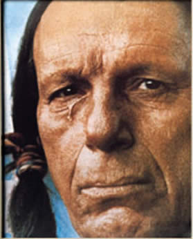
Thursday, February 4, 2010. Kaplan, Louisiana.
I'm scheduled to go to the Kaplan Museum, Le Musee de Kaplan, this morning. In preparation for the visit I check out Kaplan on Wikipedia and discover a wonderful bit of information no one has mentioned heretofore. Kaplan is the birthplace of none other than Iron Eyes Cody, the Indian with the tear running down his cheek in the Keep America Beautiful public service commercial from the early 1970s. Iron Eyes, born in 1907, acted in a many movies, going back to 1930 or earlier. He was in a couple of episodes of The Cisco Kid in the 50s. But that tear on his cheek made him one of the most iconic Indians of my generation, second only to Jay Silverheels, the guy who played Tonto on The Lone Ranger. But here's the kicker. He wasn't an Indian at all. He was Sicilian, born Espera Oscar de Corti. His parents had a store of some kind in Gueydan, the next town west of Kaplan. Most of his life he dodged the rumors of his non-Indian heritage, doing it up to the hilt--he married a Native American woman and they adopted several kids, all of them Indian. He even chanted in the background on a song on a Joni Mitchell album. Quelle blague, as they say in French. Old Iron Eyes died in 1999 and is buried out in Hollywood. (By the way, Iron Eyes must have grown up crying over all the trash in the ditches here in Louisiana.) Well, in the immortal words of Doug Keeslar, "I can't make a full-blooded Indian out of any of these farts."
At the Kaplan Museum I meet Shirley Landry and Vicky Betts and Vicky gives me the grand tour. Lots of local artifacts and historical stuff. Kaplan has its own telephone company, and Vicky remembers when you'd pick up the phone and the operator would answer, just like on the old Lassie shows. Over the display on the local Catholic church, Holy Rosary, there's a double barreled shotgun. Vicky explains to me that back in the 20s and 30s one of the early priests, Father Brise, used to fire it in church over the heads of rowdy parishioners, yelling "Kneel!" Hearing that anecdote I can't help thinking about Abrom Kaplan, the town's Jewish founder. It must have taken some fortitude to live in an overwhelmingly French Catholic town where the priest wielded a shotgun and probably taught from the pulpit that Jews were a bunch of Christ-killers. And small comfort that Michael the Archangel was Jewish before he became a Catholic saint.
Also at the museum is a display of about a dozen paintings by local artist Tony Mayard, from Abbeville. As I'm admiring them, none other than the artist himself comes in. Tony is also the curator of the Abbeville Alliance, and had heard about my walk from Cheryl. With him is Jean Frigot, the curator of the Erath museum. So I spend some time chatting with them. With Mr. Mayard's permission, I have attached photos of three of his paintings. The top one is a portrait of Clementine Hunter, a primitive painter who lived on a local plantation. Tony has painted the buildings in the background in her style, as a tribute to her. Next is a portrait of George Rodrigue, known as the "blue dog painter." Here Tony has inserted a few blue dogs onto the cow in the background. And the third one is my personal favorite, called "Penelope." I'm particularly impressed by his use of color. And thanks for your time, Tony.
Vicky mentions that Kaplan, like Franklin, had a German prisoner-of-war camp during World War II, one of several in this region.
Later in the afternoon I happen to be driving through Gueydan and stop in their museum. Tony Mayard and Jean Frigot are there. Tony has a painting on display, one of ten versions of a photograph of three women in a boat, fishing. By now I'm quite biased in his favor, but I do believe his rendition of the photo is the best, for his technique and use of color. I don't know if they're judging the ten paintings, but he gets my vote.
Friday, February 5, 2010
Day 78: St. Michael the Archangel

[A note of explanation regarding the timing of this and subsequent posts: I got lazy during my stay with my friends and didn't do much on the blog. Then last Saturday, back on the road, I discovered that the broadband internet thingy I plug into the computer no longer worked. This wasn't surprising, exactly, because it was a device my wife had been given by an employer she no longer works for, and we expected them to cancel the service at any moment, which they finally did. So now I'm sitting in a bookstore on my day off, catching up. At some point I'll subscribe to the mobile service myself, but in the meantime the blogging will sort of lurch along.]
Delcambre to Kaplan. 19.8 miles/1404 total
Wednesday, February 3, 2010
It's early. I’m headed out from Delcambre to Kaplan, through the town of Erath and the City of Abbeville.
Temperature is in the high 40s, expected to get into the low 60s, overcast.
I’m getting an early start because I am staying with my friends John and Joyce Carbaugh in Kaplan and Joyce drove me to the beginning point of today’s walk on her way to work. I’ll be walking to their house, so there’s no need to use either of my vehicles. A real luxury.
I’ve been with the Carbaughs since Saturday night, being immersed in the local culture and cuisine. Boudin, oysters, shrimp, crawfish etouffee, cracklins, and several other delicacies. The best boudin comes from Best Stop in Scott, just west of Lafayette. (For European readers, this is strictly boudin blanc; the blood sausage isn't readily available.)
John took me down to the Gulf of Mexico and to see some of the after effects of Hurricane Rita, which came less than three weeks after Katrina and did much more damage to this part of the state. Lots of flooding—houses picked up by the water and deposited elsewhere, buildings damaged or ruined. And of course rebuilding, sometimes higher and better, and sometimes just the same as before.
John is a teacher at Kaplan High School, and on Monday I spent a few hours there talking to students and faculty about the walk. His classes have been following the trip on the blog, so they know something of what I’m doing. I got the royal treatment, including some t-shirts, and the mayor sent over a letter and some pins with the town name on them. Altogether a great time. A friendly and open-hearted group. Thanks again.
A short time into the walk I enter Erath, veering off the Louisiana 14 bypass and going into the downtown. Erath is a town of a little over 2,000 that runs along the railroad tracks, on both sides. It had its centennial in 1999, so it’s a relatively new town. It calls itself La Porte d’en Arriere, which I think means the back door. Sounds a little kinky.
Erath has a museum, the Musee Acadien, but it’s only open in the afternoon, and it’s not even 9:00 a.m. yet. Local musician D. L. Menard was nominated for a Grammy for album of the year in the folklore category back in 1993.
On the way out of Erath, under a line of relatively young live oaks, is a historical marker. Acadian Prairie Settlement. Acadians obtained land here around 1781. Even though Erath isn’t very old this is the site of the first southern Louisiana prairie community.
On down Louisiana 14 I enter the city limits of Abbeville. First thing I see is the Chris Crusta Memorial Airport. At the 14 bypass I stay to the left in order to go through the center of the city. Abbeville, a city of about 12,000, is the seat of Vermilion Parish, and the birthplace of Robert Charles Guidry, a/k/a Bobby Charles, the man who wrote such songs as "See You Later Alligator" and "Walking to New Orleans." He died only a couple of weeks ago.
The interior of the Vermilion Parish Courthouse is clean but rather drab, for my taste. It has marble wainscoting and the paint above it is an institutional blue-green. I decide not to go up to check out the courtrooms, and maybe I'll miss something, but what the hell. In the hallway is an oil painting of Father Antoine Desire Megret, 1797-1853, founder of the city of Abbeville. Several other paintings adorn the walls, depicting scenes from 19th century town life. The exterior of the building is more impressive, built in what I suppose is a French colonial style from the turn of the century, with shuttered windows and large columns.
Down Concorde Street from the courthouse is Magdalen Square. At the corner there's a handsome building housing the Bank of Abbeville. Sort of Romanesque, with a couple of turrets, painted terra cotta and cream, with striped awnings over the windows.
In the park is a statue of Pere Megret. The pedestal tells the story, in English and French. Antoine Megret was a Capuchin missionary sent to Louisiana from France in 1842, to Vermilionville, now Lafayette. In 1843 he purchased some land here, in a village called La Chappelle, and started St. Mary Magdalene Church. He renamed the village Abbeville, after his home town in France. Pere Megret pretty much designed and built the city. In 1853 there was a yellow fever outbreak and the good father ministered to its victims, becoming the 73rd and last person to die of the disease. He is entombed under St. John’s Cathedral in Lafayette.
I go over to the church. This version, the third, was built after the previous one was destroyed by fire in 1910. Some nice stained glass windows inside, depicting miscellaneous saints of interest to the French, like St. Louis--King Louis IX of France.
I go over to the Abbeville Cultural and Historical Alliance Museum and Art Gallery. Almost an hour later I come out, having had a great conversation and tour of the place by Cheryl Jeanfreau. The exhibits included some aerial shots of Abbeville, Erath, and Delcambre taken after Hurricane Rita, showing the extensive flooding.
Here in Abbeville, every November, they have an omelet festival, staged by the Confrerie de l’Omelette Geante, in which they set up a huge pan and use over 5,000 eggs and other ingredients to make a giant omelet. It commemorates something involving Napoleon’s army, where the town of Bessieres in France made a giant omelet for the soldiers. People from cities in other countries that also celebrate the giant omelet come and participate. The cult of the giant omelet.
I learned a good deal more about Abbeville and the local area from Cheryl. Now I must get back on the road to finish the walk. Just as cotton and sugarcane littered the roadside in previous places, I now see rice all over the place, spilled from harvesters and trucks. This a very big rice growing area.
At 15 miles I enter Nunez, a spot on the map and on the road. I stop at the Nunez Quick Stop for a little pick-me-up. Nunez has the Quick Stop and some houses. Now I’m back out in the country, going past flooded rice fields. Little red things that look like buoys stick up out of the water. These are crawfish traps. Fishermen in small flat-bottomed boats go out onto the water and collect the crawfish and reset the traps. Later, when the rice has begun to sprout, the fields will be drained. I still need to find out more about rice farming.
I walk past Kaplan High School, where I visited on Monday, and now I’m officially in Kaplan, a town of about 6,000. This town is named for Abrom Kaplan, who bought a plantation around here in 1901. He must have been rich as hell and named the place after himself.
Kaplan unfolds typically. I pass the Piggly Wiggly and the Family Dollar. A sign says “Please Elect J. J. Landry Mayor of Kaplan.” I pass the Cajun True Value Hardware and G & H Seed Company. I’m going out on a limb to guess that the initials G and H stand for Guidry and Hebert, two very common names. You heard it here first, folks. Correct me if I'm mistaken.
At the intersection of Louisiana 14, called Veteran’s Memorial Drive, and Cushing Street I turn north into the center of town. A large sign proclaims that Kaplan is the home town of Sammy Kershaw, a country music singer (only distantly related to Doug Kershaw, another Louisiana singer who had a few Cajun crossover tunes back in the 60s). Sammy ran for Lieutenant Governor in 2007.
Several blocks up Cushing I notice that on the front step of the Kaplan Police Department there’s a statue of St. Michael the Archangel. I find the presence of this religious image on municipal property so arresting that I stop to snap a photo of it. As I’m walking on up the street a cop comes out of the building and calls to me. He gives me the old “Excuse me, sir,” which I recognize as copspeak for “Hey! Come back here, now!” I oblige and walk back. He asks me why I took a photograph of the front of the police station. I ask him if it’s against the law to take a photo of the front of the police station. At first he says yes, but then I think he realizes how silly that sounds, so he just asks me again why I did it. The thing is, I really don’t want to tell him I am documenting the Town of Kaplan’s rather obvious violation of the First Amendment separation of church and state, because I know that if he doesn’t know enough about the law to know that I have a right to take a picture of the front of the police station, then he sure as hell isn’t going to know much about the First Amendment. So I ask him if there’s anything else, and when he doesn’t answer I continue on my way.
I wish to emphasize that this policeman was not surly, or even impolite. Just a little confused, I think. By the way, I gather that St. Michael is the patron saint of policemen, not that that in any way permits Kaplan to put a religious statue on municipal property. And he's no "soft saint" either. He's kick-ass all the way. Armed and dangerous, like the police.
Monday, February 1, 2010
Day 77: Serving Your Religious Needs

Jeanerette to Delcambre. 21.2 miles/1384.2 total
Saturday, January 30, 2010
I'm leaving from the parking lot of the Family Dollar store in Jeanerette heading through New Iberia on 182 and then down Louisiana 14 to Delcambre.
It's cold and overcast. The storm front yesterday was followed by a blast of air from the north. Overnight it got down to about freezing and right now the temperature is 41 with a stiff breeze from the north. From walking in a short-sleeved shirt two days ago it's back to wearing layers under a hooded fleece-lined sweatshirt. But this is only temporary, and for most readers the 40s doesn't sound bad for late January.
In short order I'm out of Jeanerette city limits and into the country, past burned cane fields and cow pastures. I go by a historical marker for Beau Pre, a house build around 1828 and bought in 1830 by John Jeanerette, the first postmaster, for whom Jeanerette was named.
Next I come to the small cemetery of the St. James Baptist Church of Lydia, Louisiana, which is located a few miles southwest of here. Just a few dozen graves lined up alongside the road, and containing such notables as Ananias Johnson, Sr.; James "Coal Oil" Moore, Sr.; and Ivory "Bro-Z" Henderson.
I pass St. Jude Cemetery, another small one, where Archbishop Julia Lewis is buried. Archbishop of what, I don't know. Maybe Canterbury or York. But she dwelt among us until 2008 and is laid to rest here.
The countryside didn't last long, and now I'm in exurban New Iberia. I stop at the Chevron Food N Fun store. Back out on 182 I spot a new road kill species, a beaver. At least the tail looks flat and leathery like that of a beaver, but the fur is lighter than I thought it would be. The rest of the body is somewhat mangled, but I'm guessing beaver, Castor canadensis, despite its sandy color. The beaver, by the way, is the world's second-largest rodent, next to the capybara. This particular specimen isn't very large, nor does its coat look attractive enough to use for fur.
At seven miles the sign says "Welcome to New Iberia, the Queen City of the Bayou Teche." New Iberia, like other towns along this Old Spanish Trial, is pretty old. It was founded when this area was controlled by the Spanish. A group of 500 settlers came from Malaga under Bernardo de Galvez, in 1779. So it was called Nueva Iberia. Then when the French took over again they changed the name to La Nouvelle Iberie. When the Americans gained control of the area the name became New Town, then later Iberia, and sometimes Nova Iberia, before finally becoming New Iberia permanently in 1847. New Iberia, a city of over 30,000, is the seat of Iberia Parish.
I'm at the corner of St. Peter and Evangeline Streets. Evangeline is a fairly common name for a street down here, and brings to mind Longfellow's 1847 long poem "Evangeline, A Tale of Acadie." It's about a girl who was part of the Great Upheaval of the 1750s and 60s, in which the British expelled thousands of French from Acadia (the area that includes eastern Quebec, New Brunswick, Prince Edward Island, and Nova Scotia). They were sent back to France or dispersed to the lower colonies. Some made it to Louisiana, where they became known as Cajuns. In fact only a few thousand of the Acadians who left Canada came here, and when they arrived they were encouraged by the French and Spanish who were already here to settle in the western part of Louisiana. That small group of settlers were the ancestors of the present-day Cajuns, which made for, shall we say, a rather small gene pool. As a result, certain surnames, such as Landry, Guidry, Broussard, Hebert, and Trahan, are extremely common hereabouts.
For its part, France was less than supportive of the Acadians, leaving them more or less at the mercy of the British. In fact France effectively abandoned its claim to the French parts of Canada (referred to by Voltaire and others as "a few acres of snow") in exchange for the sugarcane-rich Caribbean islands of Guadeloupe, Martinique, and St. Lucia, being held by the British.
At Ann St. and St. Peter, I spy a sign for a store called Rosary House, "Serving Your Religious Needs Since 1946." (I imagine someone answering the phone, "Rosary House, Dick speaking. How may we serve your religious needs?") Well, I can't resist that slogan, so I cut up to the street that runs between the two one-way sides of 182 and go in. Rosary House is chock full of Roman Catholic religious stuff--statues of saints, crucifixes, autographed photographs of Jesus and the Virgin Mary, the whole schmear. After a few minutes of browsing I settle for a 90-cent refrigerator magnet of St. Christopher carrying the baby Jesus, as good a talisman for a wanderer as there could be. I expect it to have been made in China, but surprisingly the package says it was made in Cleveland, Ohio.
Back out on the street I take the middle way as far as Center Street, Louisiana 14, at which point I'm scheduled to turn left out of town. But I take a few minutes to walk through the downtown of New Iberia. I go by the Weeks mansion, erected for David Weeks between 1831 and 1834. Weeks was big around here, evidently. Downtown the buildings have some of the typical Spanish balconies and wrought iron railings, and the street signs are in English, Spanish, and French.
My little turn around the city center brings me back out onto St. Peter Street and the Church of St. Peter, which looks like it dates from about a hundred years ago, in what I think might be a sort of Spanish colonial style.
Back out on Louisiana 14 I pass the old high school, the interior of which has been turned into apartments. I wonder how it feels to live in what used to be some math classroom, or maybe a locker room in which generations of kids have jabbered and farted and snapped towels at one another in the shower.
On the outskirts of New Iberia things begin to get a bit more spread out. It's a succession of farms, mobile homes, and occasional businesses. At 19 miles I come to a Vietnamese Christian church of some kind, at the intersection of 14 and Rip Van Winkle Drive.
A couple of miles later I arrive at the bridge at Delcambre. The smell that wafts toward me is that of slightly rotten shellfish. The bridge is a vertical lift bridge, where the roadway lifts straight up, pulled by a system of pulleys and counterweights. They're fairly common around here for the shorter spans.
My walk today will take me only about three blocks into the City of Delcambre (pronounced DEL-com), where the motor home sits across Dudley Street from the Champagne grocery store. And that's that.
Subscribe to:
Posts (Atom)